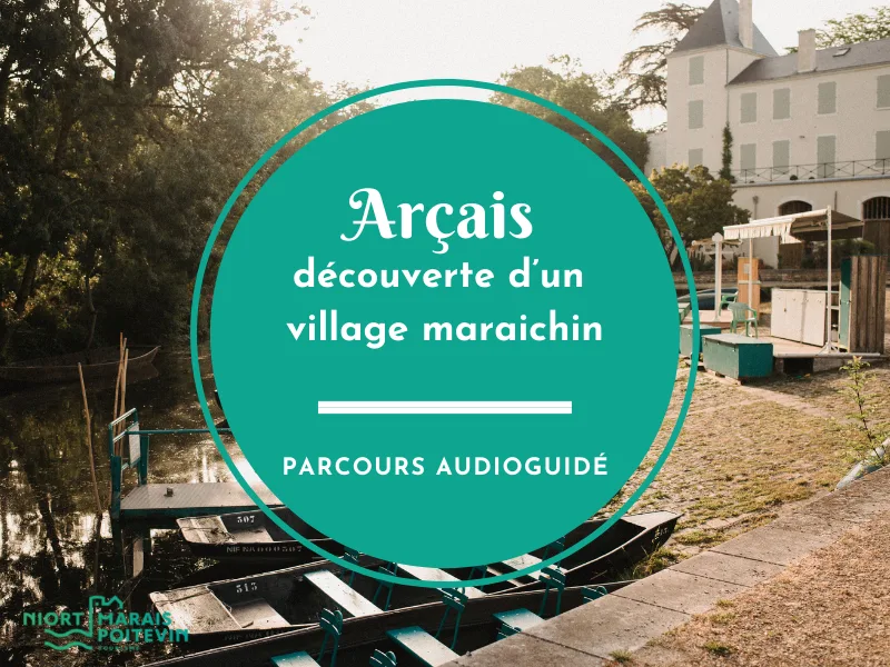
Arçais – Découverte d’un village maraichin – Parcours audioguidé sur l'application mobile
Détail de l'itinéraire
Description
Belle découverte et n’oubliez pas que vous n’êtes pas seul à emprunter les sentiers que vous allez parcourir. Nous vous invitons donc à respecter l’environnement et les habitants et ne laisser aucune trace de votre passage.
Ce parcours a été réalisé par l’Office de Tourisme en partenariat avec les élus de la commune d’Arçais et en collaboration avec le service médiation du Parc Naturel Régional du Marais Poitevin.
Crédits photos : PNR Marais Poitevin
Scénarisation et textes : Lauriane Angibaud et Amandine Louveau, Niort Marais Poitevin Tourisme
Voix : Mathilde Cornuau, Niort Marais Poitevin Tourisme
-> Itinéraire non balisé
Votre itinéraire
Étape 1 : Église – Départ
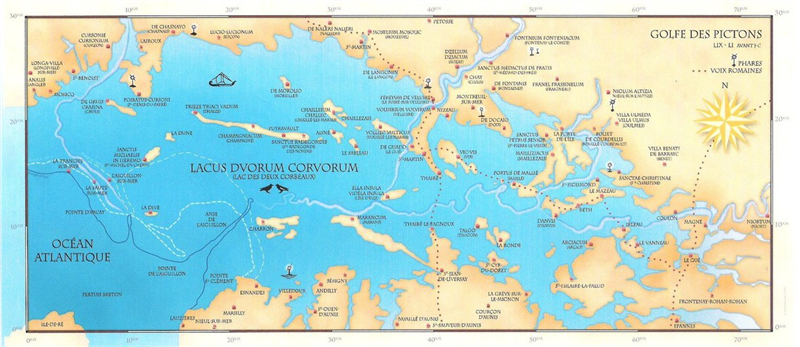
Marais Poitevin : Aménagement humain débuté au Moyen Age. Il y a 10000 ans, 1 golfe maritime : le golfe des Pictons et il y a 4500 ans encore l’océan avançait jusqu’à Niort, Arçais était à flanc de falaise. Arçais: Apparaît au Moyen Age : Les moines régissent les terres devenues marais envasé qu’ils vont assécher pour le rendre plus sain et gagner en terres cultivables. Ici, le marais mouillé : De nombreux petits canaux de navigation permettent de circuler de zone sèche en zone sèche. Label Petite Cité de Caractère : Obtenu par rapport au réseau hydraulique : près de 40 km de canaux sillonnent la commune. Jusqu’au début du XXe s. : principale voie de circulation vers l’océan. Eglise : 3è église du village (les autres ont disparu). Construction : 1860, style néogothique. Façade est : les barres de fer permettaient de faire sécher les tuyaux des pompiers. Plus bas, 1 repère de nivellement.
Étape 2 : La Poste
Le bâtiment porte encore son inscription « Poste – télégraphe – téléphone » !
Le bâtiment a été rendu par les services postaux en 2012. À ce moment-là, l’inscription aurait dû être retirée, mais le maire de l’époque, Joël Bourchenin, et les habitants se sont mobilisés pour la garder afin de conserver l’histoire de leur village. Les bâtiments de la place ont été réhabilités et ils accueillent des créateurs et artisans locaux.
Étape 3 : Carrefour Rue de la Garenne/Rue de la Mairie
1 des carrefours les plus typiques. Sur la droite, la pompe à eau : L'eau potable dans chaque maison est une chose plutôt récente, arrivée fin 19è-début 20è s.
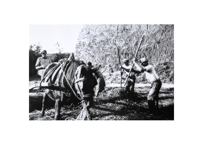
Rouleau à mogettes à côté de la pompe : rouleau à trous tiré par 1 cheval sur 1 plateforme ronde en terre battue afin de battre les céréales ou les fameux haricots blancs sans les abimer. Bouteroues : blocs de pierre aux angles des rues repoussant les roues des charrettes qui coupaient la trajectoire dessinée par le cheval attelé. Haut lieu de tournage, Arçais a accueilli plusieurs tournages : En 1968, “L’inspecteur Cadavre”, 1 épisode de la série “Commissaire Maigret” avec Jean Richard. En 2019, 1 série allemande traitant de la 2nde Guerre mondiale, “Das Boots”. La maison à gauche porte l’inscription “Café au bon coin”. Ce bâtiment a servi de lieu de tournage et les décorateurs ont peint cette devanture pour l’occasion.
Étape 4 : Rue de la Garenne
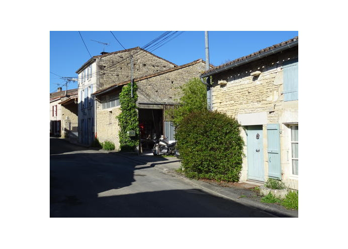
Les habitations typiques. Si elles sont organisées de façon similaire aux autres communes du marais, à Arçais, elles possèdent une particularité.
Les constructions d’autrefois étaient réalisées avec les pierres des alentours, les maisons ont ces alignements si particuliers en petits moellons : Ceux-ci étaient récupérés dans les carrières au niveau de la plaine. Pour les pierres de taille (les gros blocs rectilignes autour des fenêtres), il fallait les rapporter de Benet, à 15km de là. Elles étaient acheminées par des rouliers, de grosses charrettes tirées par des chevaux. Et ici l’humidité est omniprésente, il était nécessaire de bien isoler les maisons… Celles-ci, contrairement à la tendance moderne, étaient systématiquement protégées par un crépi.
Étape 5 : 71 rue de la Garenne
Façade droite du bâtiment : Des murs pouvaient être montés en calant des os de vache entre des moellons à la même hauteur pour accrocher les plantes grimpantes ou les treilles. Ce système pouvait aussi être employé à faire sécher des filets de pêche lorsqu’ils étaient en chanvre, un matériau plus fragile qui s’abimait plus vite si fixés à des clous plus durs.
Étape 6 : La venelle
Attention, la descente de cette venelle est très raide.
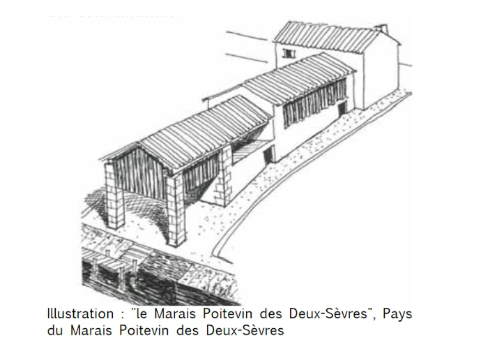
Avant de descendre, autour de vous, vous avez 1 bâtiment avec 1 partie de bardage en bois, c’est 1 grange. Parmi les matériaux couramment utilisés dans le marais pour la toiture, il y avait des roseaux : bon isolant, c’est 1 matériau très inflammable, même si les incendies étaient finalement rares. Les granges faisaient environ 9 à 10 m de haut et stockaient les cultures de mogettes, de fèves ou de foin.
Les venelles sont omniprésentes, elles mènent forcément à l’eau. Elles faisaient à peu près 1m30 de large et étaient moins pentues qu’aujourd’hui. Elles permettaient aux personnes qui avaient 1 maison qui ne touchaient pas l’eau d’accéder à la conche. Autrefois elles publiques, beaucoup ont aujourd’hui été privatisées par les maisons attenantes et le passage de la rue vers l’eau est plus compliqué et rare.
Tournez sur votre gauche.
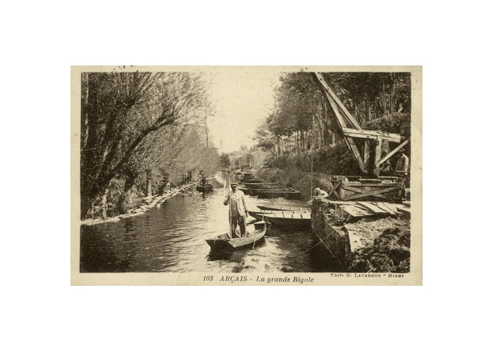
Étape 7 : Le long du canal – Faune & flore
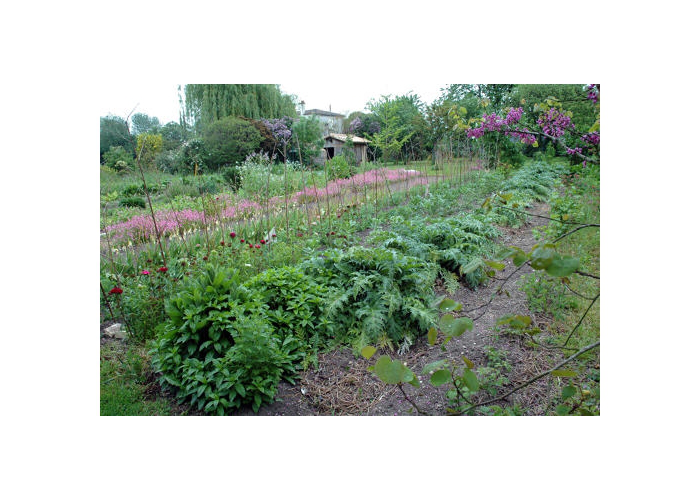
A l’époque où l’activité nautique était à son apogée, il n’y avait pas de végétation comme actuellement au niveau des chemins de halage. Il fallait qu’il n’y ait aucun obstacle sur le côté pour permettre aux barques d’être traînées par des vaches ou des chevaux. Dès les premiers aménagements, les frênes étaient taillés, les fossés curés, les près fauchés : pas de place pour la nature. Tout en marchant, tendez l’oreille et appréciez les bruits feutrés de la nature environnante. Regardez également sur l’autre rive, vous y verrez des jardins potagers. Il était commun que chaque maraichin ait son potager accessible en barque. Les mogettes constituaient une base importante de l’alimentation. C'était un déshonneur ne pas avoir une parcelle entretenue. Il fallait que ce soit propre !
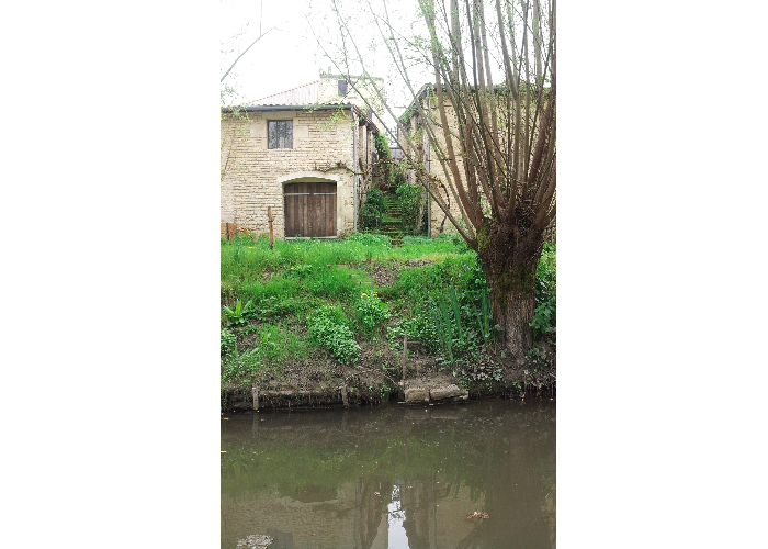
Étape 8 : La ferme maraichine
Sur l’autre rive, 1 ancienne ferme maraichine accessible uniquement en barque.
Le marais actuel tient son schéma de 1860, début de campagnes d’asséchement commandées par Napoléon III pour compléter les aménagements médiévaux. L’eau était au cœur de la vie : transport des animaux, facteur, laitier… Tous circulaient en barque. La pratique de la pêche traditionnelle, principalement à l’anguille, permettait de nourrir son foyer et le surplus était vendu. Aujourd’hui la pêche à l’anguille, ainsi qu’à la civelle, est très réglementée.
Les barques pouvaient être de différents matériaux : bois, fer ou ciment (moins coûteux). Exploiter les terres du marais est difficile et nombre d’agriculteurs ont tendance à le quitter pour cultiver des espaces plus faciles et sûrs. Autour de 1960, des passerelles ont été bâtis dans le but d’améliorer l’accessibilité aux parcelles et faciliter le travail.
Étape 9 : L’organisation des habitations
En regardant les propriétés sur la gauche, on comprend mieux l’organisation du village et des fermes. Les constructions se trouvaient proches de l’eau pour avoir un accès rapide aux conches et pouvoir aller aux champs. Les maisons d’habitation étaient tout en haut des parcelles, puis, plus bas, il y avait la grange près de l’eau, l’écurie. Chaque maison avait son accès à l’eau et à l’embarcadère.
Les poteaux de bois au bord de l’eau avec des numéros inscrit dessus correspondent aux amarrages des maisons qui en sont propriétaires. Les personnes qui vivaient plus haut dans le village descendaient par les venelles. Toute l’organisation du village se faisait en fonction de l’eau. Au niveau des jardins, des crèches à vache avec des anneaux datent des maisons d’origine. Aujourd’hui, les maisons ont beaucoup changé, mais ces crèches sont utilisées en pot de fleurs ou en soutien pour les murs.
Étape 10 : Le logis
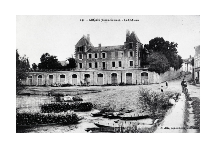
Derrière le mur d’enceinte, sur la gauche, se trouve l’ancien parc du logis. Cette demeure imposante fût construite en 2 temps : En 1820, le général Philippe Auguste Ducrocq, propriétaire du terrain, fait construire la majeure partie du logis et de ses dépendances. En 1875, il agrandira le bâtiment pour créer un pavillon indépendant. En regardant la façade, la séparation se devine grâce aux fenêtres qui ne sont pas toutes à la même distance. En dessous, les réserves constituent les fondations de l’édifice.
La plupart étaient mises à disposition des agriculteurs qui y entreposaient matériel et marchandises.
Les autres appartenaient au logis et disposaient d’un accès direct à ce dernier en passant par un escalier intérieur. La grille sans porte en dessous abritait une pompe à eau qui servait aux agriculteurs. Manuelle à l’origine, un moteur électrique fut installé au début du 20è siècle.
Étape 11 : Le Grand Port
Le port était un endroit central du village.
Ici, les agriculteurs venaient déposer leurs marchandises. Apartir de là, le marais été rapidement accessible en barque. Les plots en métal, en haut du port, étaient plus nombreux et tous portaient un numéro qui correspondait à une propriété en particulier. Il y a beaucoup moins de plots aujourd’hui car au fil des changements de propriétaires, les registres notariés ont peu à peu perdu les traces de correspondance entre propriétés et emplacement d’embarcadère. Les grues présentes sur le port sont des reproductions. Le commerce du bois était important. Une fois arrivé au port, le bois tiré derrière les barques depuis le marais, était hissé à l’aide de ces grues. Accroché par une chaîne, les troncs étaient remontés à la force des bras. Il fallait ensuite tourner la grue pour que le bois soit chargé sur le véhicule qui l’acheminait à la scierie.
Étape 12 : Rue de l’Ouche
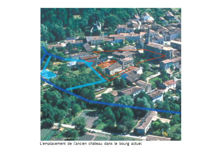
Avant de traverser la route, contrôler la circulation et soyez prudent. Un château-fort aurait été édifié durant le 13ème siècle en contrebas de l’église et aurait été vendu en 1873. Aujourd’hui, ne demeurent aucunes traces du château en lui-même. Certaines habitations sur la droite, après l’intersection vers la place de l’église, correspondent aux anciennes dépendances du château disparu.
Étape 13 : Office de Tourisme – Final
A l’origine, le bâtiment qui accueille aujourd’hui l’Office de Tourisme, était une boulangerie. Transformé en cinéma vétuste qui n’était plus utilisé, il avait perdu sa toiture. Rénové, il a été transformé en espace d’accueil touristique suite au passage du président François Mitterrand en 1992. C’est le début des “grands travaux” afin d'entamer la “renaissance du Marais Poitevin”. En effet, depuis les inondations de 1983, la population quittait et délaissait peu à peu le territoire qui tombait à l’abandon et dans l’oubli.
N’hésitez pas à pousser la porte de l’Office de Tourisme, vous y trouverez d’autres images anciennes, des objets traditionnels, ainsi qu’une équipe de conseillers toujours prêts à vous renseigner pour approfondir votre découverte du marais !